
BETHLEHEM, Pa. — When it comes to winter storms, nothing is more hazardous than ice, and there’s plenty of it in the Lehigh Valley forecast this week.
The National Weather Service is calling for “quite the icy slop of wintry precipitation across the region, including both sleet and freezing rain” as a quick-hitting winter storm will descend upon the region late Wednesday.
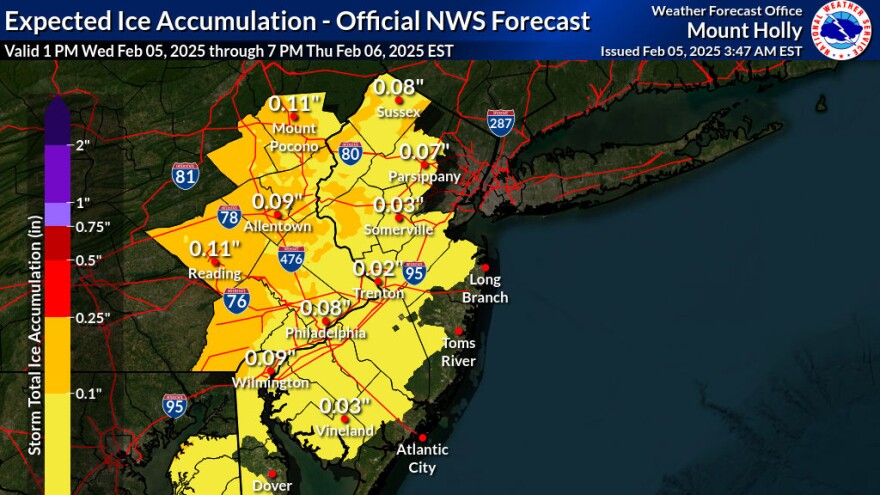
A winter weather advisory is in effect from 11 p.m. Wednesday night until 1 p.m. Thursday for total snow and sleet accumulations up to an inch and ice accumulations of one-tenth to two-tenths of an inch.
The onset of precipitation in the Lehigh Valley is expected to be in the overnight hours.
EPAWA meteorologist Bobby Martrich said we also could see a “carbon copy” of the system this weekend.
The big concern is the amount of freezing rain in the forecast.
Exactly what it sounds like
Freezing rain is exactly what it sounds like, Martrich said in a phone call Monday.
Rain falls as liquid and freezes on ground, coating everything in a slick glaze and making roads and walkways extremely dangerous.
The setup involves warm air overriding colder air at the surface, meaning rain falls into that layer of warm air before meeting a layer of freezing air hugging the ground.
Freezing rain will occur when the layer of cold air is so thin that raindrops don’t have enough time to freeze before reaching the ground.
Instead, that water freezes on contact with the surface.
How much ice can we expect?
Meteorologists use words like “accrete” or “accrual” to describe ice buildup, because it doesn’t accumulate like snow.
Instead, it freezes in layers and is measured from the thickest and thinnest portion of ice coating an object from one side to the other.
Ice buildup can weigh down and snap power lines and tree branches, but it takes a significant amount — about a half inch of freezing rain — to see those types of effects.
Luckily, forecasters believe the Lehigh Valley should see around or just over a tenth of an inch of ice from Wednesday’s system.
It won’t be a lot of ice, but it’s likely to cause school delays and closures Thursday morning.
Due to the forecast, Allentown said its city curbside collection is cancelled Wednesday night, and residents should refrain from placing trash and their bulk item at the curb.
On Sunday, Feb. 9, trash and recycling may be placed out, which includes up to 10 bags of trash or four 32-gallon containers of bagged trash, bulk items and curbside recycling within a city issued green container.
The good news
If you’re looking for a silver lining in this treacherous forecast, consider the science behind the weather.
As raindrops freeze, they release heat into the environment, warming the atmosphere.
The buildup of freezing rain has a limit unless the atmosphere finds a way to bring in more frigid air or cap the cold air at the surface. Otherwise we just wait for the invasion of warmer air.
Forecasters say by Thursday morning, most places will be in the process of changing over to primarily rain as surface temperatures rise above freezing.
By Thursday afternoon, temperatures should rise well into the 40s in the Lehigh Valley as a strong surge of warm air occurs. So plain rain will be anticipated by then.
“The timing and specifics of the changeover are less certain though, but greatest confidence with the prolonged duration of wintry precip-types lies over our northern Pennsylvania and northern New Jersey counties,” the weather service said in its latest forecast discussion.
