BETHLEHEM, Pa. — Wind speeds increased Thursday afternoon, prompting the National Weather Service to issue yet another alert across the region.
A wind advisory was extended until 4 p.m. Friday in the Lehigh Valley and surrounding areas, with winds 15 to 25 mph and gusts of 35 to 50 mph expected.
The advisory covers parts of Delaware, New Jersey and Pennsylvania, warning gusty winds will blow around unsecured objects.
Tree limbs could be blown down, resulting in power outages, the advisory states.
A few weeks ago, thousands of utility customers lost power after punishing winds ripped through the region in the wake of a winter storm.
Advisory, Watch, Warning
What’s the difference between a wind advisory and a high wind watch or warning for our region?
The weather service has different criteria for each:
Wind advisory: Wind gusts of 46 mph to 57 mph, or sustained winds of 31 mph to 39 mph for one hour.
High wind watch or warning: Wind gusts of 58 mph or greater, or sustained winds of 40 mph or greater for one hour.
Forecasters say a tight pressure gradient will remain in place across the region and several models are depicting the low/mid level jet — a fast-moving ribbon of air low in the atmosphere — over or near our region through much of the day Friday.
“Looking at some model soundings, there is potential for 45+ mph winds across much of the area,” the NWS forecast discussion said.
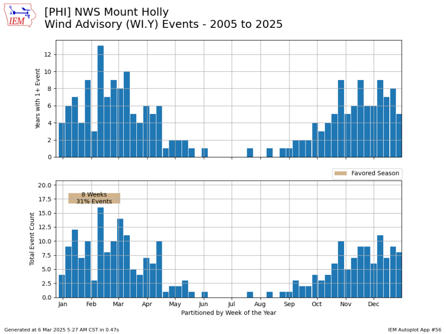
Wind advisories by week
The featured chart below looks into the frequency of wind advisories for the Lehigh Valley by week of the year, with the top panel showing the number of years since 2005 that have seen at least one event.
The bottom panel shows the total number of events in the area, defined by each individual issuance by the NWS Mount Holly forecast office.
The chart shows that winter is clearly the most active for strong winds, with the summer months nearly void of this type of alert.