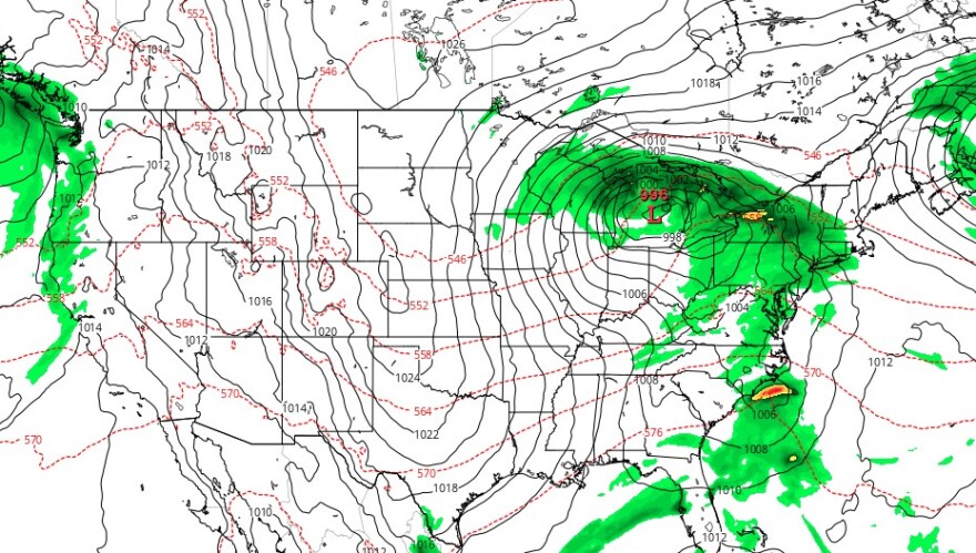
- A storm system targeting the region will bring rain through much of Saturday
- The bulk of the precipitation will arrive in the late morning, with the heaviest rain Saturday afternoon and evening, forecasters say
- Sunday should be dry, thanks to the progressive nature of the system
BETHLEHEM, Pa. — Bethlehem’s Harvest Fest will initiate a Main Street takeover Saturday that will include wine-, beer- and soup-tasting trails, along with food and musical acts.
But like it or not, the one-day event — and anything else going on in the region Saturday — also will include rain.
A potent system is still on the way to the area, the National Weather Service warned Friday, referencing a storm forecasters have been talking about for almost a week.
“That has been the forecast all week, that has not changed,” EPAWA meteorologist Bobby Martrich emphasized in his latest video update.
“Saturday is not a good day,” he said. “The system moving toward us is going to redevelop to another coastal low offshore.”
But a few things have changed concerning the arrival and departure of the storm that will help salvage the back half of the weekend.
EPAWA's 10/13 and week ahead outlook, covering:
— Bobby Martrich | EPAWA (@epawawx) October 13, 2023
■ Timing the rain Saturday and total rainfall expected
■ 2nd half of the weekend dries out and is salvaged
■ Micromanaging the NLCS Monday/Tuesday in Phillyhttps://t.co/FXeBNApH5U
Timing, precipitation
“We do have periods of rain coming in here on Saturday,” Martrich said. “Saturday is going to be a wash from start to finish.”
That includes some light showers in the predawn hours overspreading the area. But the bulk of the precipitation will arrive a bit later than initially believed, with on-and-off periods of rain at the start.
“Expect that rain associated with this system will move in west to east mostly around the late morning to early afternoon time frame, which is a slightly later start time than it was looking like a day or two ago,” the weather service said.
Martrich said the bulk of the system and the heaviest rain will come in the afternoon and evening, with the progressive nature of the storm allowing it to hustle out of the area in a hurry.
“By the time we get to 8 a.m. Sunday, maybe a leftover shower in our far southeastern areas,” Martrich said. “For the rest of you, clouds giving way to sun.”
That includes the Lehigh Valley, where Sunday is now shaping up to be a fairly nice day.
Expected rainfall totals, temperatures
Total rainfall amounts from Saturday through early Sunday are generally expected to be in the 1 to 1.5 inch range across the area, according to the weather service.
The highest amounts are favored over southeast Pennsylvania, the weather service said, while Martrich said he expects lower rainfall totals of a half-inch to an inch at most.
“You might have isolated cases where it goes barely above an inch,” he said.
Temperatures through the weekend are expected to be chilly due to the rain and clouds, with highs Saturday mainly in the 50s.
Sunday should be a few degrees warmer, but still below average for this time of year.


