BETHLEHEM, Pa. - Tired of the heat? Brace yourself.
The National Weather Service predicts hot and humid conditions Sunday in the hottest day of the heat wave so far. Saturday won't be a picnic, either.
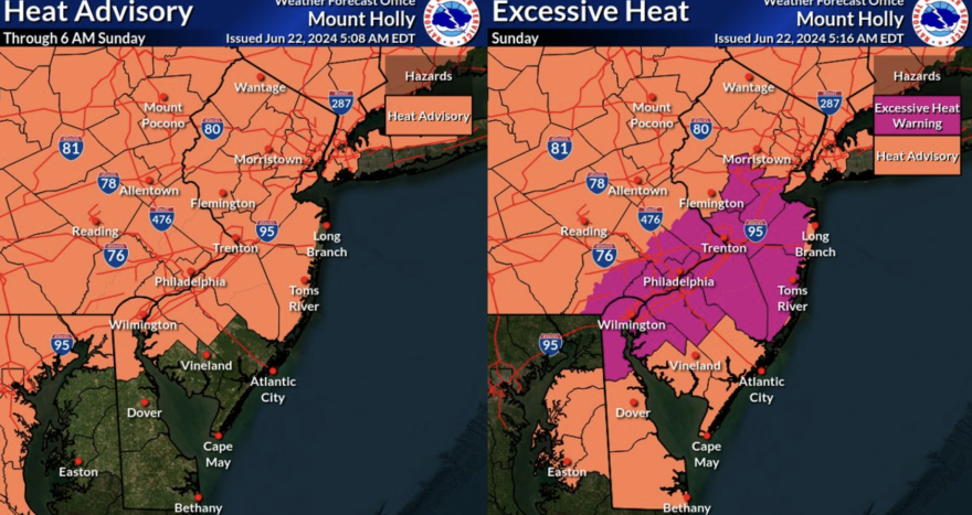
Excessive heat warnings have been posted in parts of the northeastern U.S. with heat indices of 105 to 110 degrees. Forecasters issued an excessive heat warning for southeastern Pennsylvania and parts of New Jersey.
“This, combined with the nearly week long stretch of heat, are going to result in dangerous conditions outside for Sunday as the effects of heat stress on the body can be cumulative,” the weather service said in its daily forecast.
Saturday is expected to hit a high of 96 in the Lehigh Valley, with heat index values as high as 101. There’s a chance of showers and thunderstorms Saturday night, mainly before 11 p.m.
A cold front will move through Sunday night/early Monday, bringing with it the chance of severe weather. Thunderstorms with damaging wind gusts are possible. The Lehigh Valley is at a slight risk (two out of five) of strong to severe thunderstorms.
In addition to the heat, there is the chance for some severe weather this afternoon and especially tomorrow afternoon/evening. Damaging winds and heavy rain are the primary threats. #NJwx #PAwx #MDwx #DEwx pic.twitter.com/SNV97yTF3C
— NWS Mount Holly (@NWS_MountHolly) June 22, 2024
Those storms could produce heavy rain capable of dumping an inch or two quickly, though there is little risk of flooding.
“It will feel much more comfortable on Monday with dew points back into the 50s and temperatures getting into the mid to upper 80s,” said the weather service’s latest forecast discussion. “Some scattered showers and thunderstorms are possible Monday, but not as severe as the threat Sunday.
Temperatures Monday night will drop into the 60s.
After Monday’s reprieve, above-normal temperatures will continue for the long term but not as uncomfortable as this week. Wednesday will be the outlier next week and looks to be the hottest day in the long-term forecast, according to the weather service.
High temperatures through most of the extended forecast appear to be in the upper 80s to low 90s.
MORE: Worried about your plants in extreme heat? Here's what the experts suggest