BETHLEHEM, Pa. — As the map beneath their feet began to fade and change Saturday afternoon, sisters Evelyn and Olivia Detore squealed with excitement.
“It disappeared,” 8-year-old Evelyn said.
“It’s powerful,” 6-year-old Olivia responded.
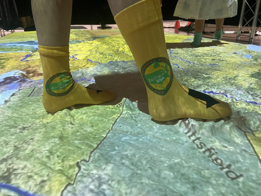
The pair were some of the first to experience the National Scenic Visitors Center’s “Earthwalk Explorer” Saturday at the Banana Factory Arts and Education Center, 25 W. Third St. The free, tactile exhibit is centered around a 3D map of the northeastern U.S., from North Carolina to New Hampshire, with projectors showing layers of parks, forests, highways and more.
“The texture difference — feeling that under your feet — I hope it starts some questions, ignites some interest in seeing the natural world around us.”Jena Detore, of Holland Township, N.J.
“I thought this would be a great way to show them the landscape,” said Jena Detore, mother to Evelyn and Olivia. She drove the trio from Holland Township, N.J., to experience the exhibit.
“The texture difference — feeling that under your feet — I hope it starts some questions, ignites some interest in seeing the natural world around us.”
‘The exact same idea’
The idea for the map came to Mary Ellen Snyder, executive director and co-founder of the National Scenic Visitors Center, decades ago, she said.
But it wasn’t until more recently, when she was speaking with Dan Beaupre, who led the National Geographic Bee, about the idea that plans began to take shape.
“I went to him when I retired,” Snyder said. “I said, ‘I had this idea 30 years ago. Now, I'm going to work on it. What do you think?’
“He said, ‘I had a guy in here three weeks ago with the exact same idea.’”
That person was Matt Kambic, a writer and musician. Together, Snyder and Kambic founded the National Scenic Visitors Center and went to work creating the “Earthwalk Explorer.”
“At that time, our idea was to make one the size of a football field, but now that we know how to do it, it's just too big,” she said. “Maybe somebody will do it someday. We’re taking it one step at a time.”
The map, measuring 8 feet by 16 feet, is made from polyurethane rubber. It was created by Northampton Community College’s Fab Lab.
“We took GIS data, we fed it into a CNC router, which means computer-driven,” Snyder said. “The router created the mold in pieces. Then the mold was assembled. The rubber was poured.
“We now have a 560-pound map.”
Over the last three years, the exhibit has been displayed at the Da Vinci Science Center and Northampton Community College, as well as in Lancaster, Harrisburg and Pittsburgh, among other locations.
“It's very sturdy. It's washable. It's just wonderful material — it’s holding up beautifully.”Mary Ellen Snyder, executive director and co-founder of the National Scenic Visitors Center
So far, more than 20,000 people have walked across its surface.
“It's very sturdy. It's washable,” Snyder said. “It's just wonderful material — it’s holding up beautifully.”
‘A slow reveal of geographical knowledge’
Inside the Banana Factory’s Crayola Gallery, a large rectangle of metal scaffolding enclosed the map, hidden further behind black curtains.
Before participants can enter, they must take off their shoes, but no bare feet are allowed — socks are mandatory.
A mat outside the entrance includes the outlines of three different size feet, so explorers can estimate how far they’ve traveled compared to the map’s scale. The largest outline shows 42 miles, followed by 30 miles, then finally 23 miles for the smallest.
Six projectors, positioned above the map, change what’s shown below as a narrator walks visitors through the experience. The map shows highways, parks, boulder fields, old-growth forests, the route of the Appalachian Trail, migratory bird patterns and more.
“It’s sort of a slow reveal of geographical knowledge,” Snyder said. “People are walking around saying, ‘Oh, this is where we went camping,’ ‘This is where grandma lives,’ ‘This is where we want to go hike.’”
At the end, everything human-made on the map disappears, leaving the landscape exactly as it was before human intervention.
“The explorer tells stories of geography, history, nature and culture,” Snyder said.
The exhibit runs through Saturday, July 27. Visit the Banana Factory’s website for more information.