

BETHLEHEM, Pa. — It was above 90 degrees in the Lehigh Valley on Monday for the fourth consecutive day, and for the 12th day in the past 17.
In that sultry and sweltering stretch, two of those days reached a high of 89. Several others pushed into the mid-to-upper 80s.
Overall, there also have been two official heat waves this summer. The first ran from June 18-23, when the average high temperature was 94 degrees and the area broke multiple heat-related records.
In this, our second official heat wave of the summer, things have been much the same. Average highs have run around 92 degrees in a four-day stretch, with a heat advisory in effect until at least 8 p.m. Wednesday.
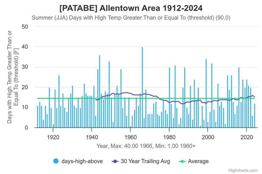
Yes, it’s July, our hottest month of the year on average. But the Lehigh Valley now is in its 13th day of 90-plus temperatures this summer, well on the way to surpassing the average of 14.42 days in the 90s for records that date to 1912.
At this point, we’re barely trailing our 30-year average of 15.23 days in the 90s for meteorological summer (June, July, August).
Reminder, it’s only July 9. Summer has a long way to go.
Suffocating, not record-breaking
With this heat, perhaps you’re wondering how many 90-degree days have occurred in a row, historically.
You might be surprised to learn that 2024 isn’t close to challenging that record.
There were 19 consecutive 90-degree days in the Allentown area from June 27 to July 15, 1966.
There were 11 consecutive days from July 23 to Aug. 2, 1999.
Twice, in 1943 and again in 1980, there were 10 consecutive days when temperatures reached 90 or above; at least eight years saw stretches of nine consecutive days.
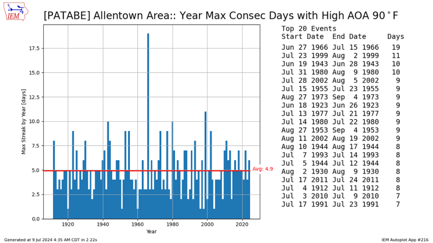
In this suffocating week of heat and humidity, we’ll need at least seven consecutive days to meet the low end of the longest daily streaks of meeting the 90-degree threshold. Two years — 2010 and 1991 — have achieved that mark.
The forecast for the rest of the week calls for temperatures in the 90s through at least Wednesday, and approaching 90 again Thursday. If we get there, we’ll hit that seven-day stretch.
Temperatures may dip below 90, briefly
As the heat advisory continues, Allentown again will open city pools from 12 to 7 p.m. Admission will be free to residents and season pass holders only as capacity allows, with address verification required.
City spray parks are open from 11 a.m. to 8 p.m. daily at no cost, and cooling stations operated by Allentown Fire Department will be available from 11 a.m. to 3 p.m. at Roosevelt Park, Jordan Park and Union Terrace.
Public air-conditioned buildings also are open in the city for anyone in need. The list includes:
- Allentown Public Library, 1210 Hamilton St., from 8 a.m. to 8 p.m.
- Cumberland Gardens Community Room, 501 E. Cumberland St., from 3:30 to 7 p.m. (subject to change)
- Executive Education Charter School, 555 Union Blvd. (use the Union Boulevard entrance) from 8 a.m. to 1 p.m.
- Lehigh Valley Active Life, 1633 Elm St., from 8:30 a.m. to 4:30 p.m. (enter through the doors facing the parking lot)
- PPL Center lobby, 701 Hamilton St. (enter through the main gate sliding doors) from 10 a.m. to 5 p.m.
Even as the worst of the heat breaks later this week, forecasters say there won’t be much of a reprieve, thanks to the very humid air mass in place.
According to the National Weather Service, the timing of the remnant low of what was Hurricane Beryl looks to get closest to our area Wednesday night into Thursday, and the greatest concentration of showers and thunderstorms should be tied to it.
There could be a zone across northeast Pennsylvania into northwest New Jersey where convection may train and/or back build for a time, enhancing the very heavy rain/flash flooding risk, the latest forecast discussion said.
In addition, storm potential resulting in a locally strong wind risk “looks to be greatest near and north of I-78,” the discussion said.
High temperatures are forecast to get back into the 90s by the weekend, and with high enough dew points, peak heat indices may reach or exceed 100 degrees in many areas again by Sunday.
