BETHLEHEM, Pa. — The storm system that brought a tornado outbreak to the South is moving its way up the East Coast.
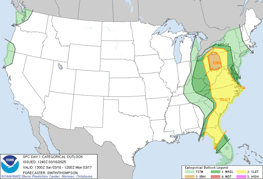
And a forecast discussion from the National Weather Service's Storm Prediction Center puts the Lehigh Valley on the cusp of a "marginal" risk of severe weather.
To the west, most of the state falls under the lower severe risk categories, which the weather services said will see "sporadic damaging wind swaths and a few tornadoes will be the primary threats this morning through dusk across a broad portion of the east."
"The threat for severe weather and severe-level gusts has diminished a bit..."Forecast discussion from the NWS Mount Holly, New Jersey
"The threat for severe weather and severe-level gusts has diminished a bit compared with what it was looking like yesterday as any instability will be mainly elevated, with the higher CAPE values staying off to the south and west," a forecast discussion from the NWS Mount Holly, New Jersey, office said.
"SPC has cut back the Marginal Risk to now only really include the Eastern Shore, which makes sense given the lack of instability."
Severe risk categories include: TSTM (thunderstorms), 1 for "marginal," 2 for "slight" risk, 3 for "enhanced" risk, 4 for "moderate" risk and 5 for "high" risk of severe weather.
Wind gusts, lightning, flooding
A previous weather outlook updated on March 14, shown by EPAWA meteorologist Bobby Martrich in his weekend video forecast, put the Lehigh Valley under a "slight risk" of severe weather.
But the current outlook depicts the area as having "a 10% or greater probability of thunderstorms."
The TSTM category means no severe thunderstorms — which the weather service defines as "measured wind gusts to at least 58 mph, and/or hail to at least one inch in diameter, and/or a tornado" — are expected.
Lehigh and Northampton counties are under a wind advisory until 9 p.m. Sunday, but the advisory warns of South winds upwards of 25 mph and gusts up to 40-50 mph that don't meet the criteria to be considered a severe thunderstorm.
Gusts still could blow around unsecured objects and tree limbs and cause power outages, the advisory said.
The NWS also noted that all thunderstorm categories "imply lightning and the potential for flooding."
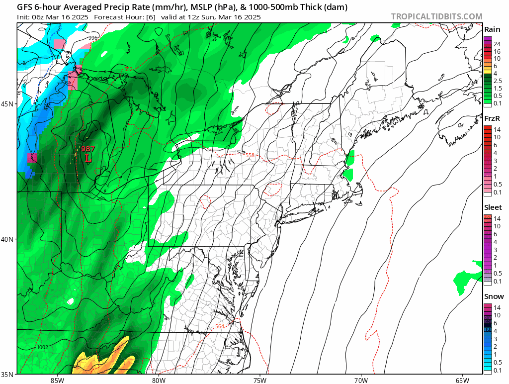
After some dense fog late Saturday night into early Sunday morning, the area is expected to see rain showers after 5 p.m., with heavier rain to follow later possibly amounting to 2 inches of new rainfall.
Don't 'focus on severe weather part'
A thunderstorm could be possible before 2 a.m., with a 30% chance of showers before 7 a.m.
"While heavy rain is possible and rainfall rates for a brief period could approach an inch per hour, not really expecting any flooding concerns given how dry it has been," the local forecast discussion said.
"Rainfall amounts when all is said and done will be around an 1-1.5" with amounts up to 2" possible near the coast."National Weather Service forecast
"Rainfall amounts when all is said and done will be around an 1-1.5" with amounts up to 2" possible near the coast."
Martrich also showed a model that depicted a similar outcome in his weekend weather update.
"This is just rainfall at this point, maybe some embedded thunder, but not really much in the way of severe weather," Martrich said of the storm after models show the storm front — what he described as "synoptic rain showers" by the time it passes through the Lehigh Valley from 5-11 p.m.
"So I don't want anybody to focus on the severe weather part of it because prior to the front even getting there, you're gonna be windy all day.
"And that's where, if you have any power outages on Sunday, it's probably gonna be from what happens before the precipitation even gets in."