BETHLEHEM, Pa. — After weeks of dry weather, and with no significant rain in the near forecast, parts of the Lehigh Valley on Thursday entered into a severe drought.
“Happy Halloween! A not so spooky forecast is in store today with plentiful sunshine and an increase in clouds late,” according to a X post from the National Weather Service in Mount Holly. “However, it will be frighteningly warm with highs in the 70s/80s where a few ghostly records may be in jeopardy this afternoon.”
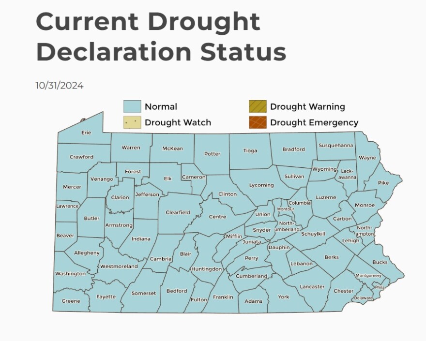
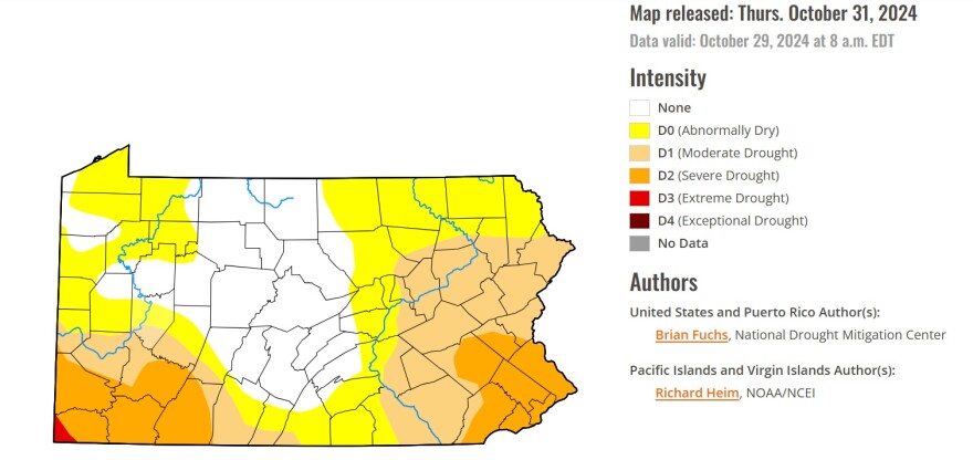
The U.S. Drought Monitor on Thursday showed all of the Lehigh Valley in either “moderate” or “severe” drought. While it’s not a surprise — the region has been parched for rain for weeks — the impacts could be widespread and severe. However, the state Department of Environmental Protection has the state listed as “normal” for its Current Drought Declaration Status.

“We are not currently in an official drought watch per DEP, [Delaware River Basin Commission], or LCA declaration,” said Susan Sampson, communications manager for Lehigh County Authority, in an email. “If we move to a watch, that is when we request a voluntary 5% cutback.”
An authority water supply report, dated Tuesday, shows two out of three monitoring points still above a drought threshold.
Both the Upper Macungie Park Quarry and the Lower Macungie Monitoring Well are within normal range. However, the Little Lehigh Creek as of Monday was classified at “emergency” levels.

The authority, a nonprofit water and wastewater utility, provides retail and wholesale service to about 270,000 people across the Valley
Moderate, severe
While the majority of Northampton County is still in the “moderate” category, or D1, the bulk of Lehigh County is now classified as “severe,” of D2.

While no area experiences a drought the same way, officials behind the monitor have been tracking historical impacts.
When an area in Pennsylvania hits “moderate” drought, honey production declines and irrigation use increases; hay and grain yields are lower than normal; trees and landscaping, as well as fish, are stressed; and wildfires and ground fires increase.
Usually, a D1 classification will cause local officials to request residents voluntarily conserve water, as reservoir and lake levels can dip below normal.
Drought monitor update: 98% of our area is in drought, including 63% in Severe Drought. 8 of our 9 climate stations are experiencing their driest calendar month on record. A few sprinkles possible tonight & some slight chances of showers return next week. #PAwx #NJwx #DEwx #MDwx pic.twitter.com/ygBBO3WFek
— NWS Mount Holly (@NWS_MountHolly) October 31, 2024
When an area hits “severe” drought, wildlife move to farms for food; trees are brittle and susceptible to insects; warnings are issued on outdoor burns; air and water quality is poor; groundwater is declining; irrigation ponds are dry; outdoor water restrictions are implemented.
‘98% of our area is in drought’
Of the National Weather Service at Mount Holly’s service area, which covers eastern and southeastern Pennsylvania and extends into New Jersey, Delaware, and northeastern Maryland, the vast majority is in a drought.
Drought monitor update: 98% of our area is in drought, including 63% in Severe Drought. [Eight] of our 9 climate stations are experiencing their driest calendar month on record.National Weather Service - Mount Holly forecasters
“Drought monitor update: 98% of our area is in drought, including 63% in Severe Drought,” forecasters posted on X. “[Eight] of our 9 climate stations are experiencing their driest calendar month on record.
“A few sprinkles possible tonight & some slight chances of showers return next week.”
While there’s a slight chance for a few isolated to scattered light showers or sprinkles possible Thursday night — a few hundredths of an inch of rainfall — a cold front moving into the area could quash it, according to the NWS’s forecast.
The cold front could bring showers Friday, forecasters said.
“A few isolated or scattered showers will be associated with the front as it passes through, but nothing widespread is expected,” according to the NWS. “This may be the best chance for some rain though for quite some time, so any rainfall that does occur will be greatly appreciated considering the worsening drought conditions.”
The next chance for rain is late next week, following above average temperatures Tuesday and Wednesday. However, it’s a slim chance, at only about 20% to 40%.
While this stretch of dry weather has already pushed Philadelphia, Trenton, Wilmington, and Georgetown into the Top 5-10 longest consecutive number of dry days on record, there’s still some time before Allentown breaks its dry-streak-record.
The consecutive number of dry days for the Allentown area is 42, from Oct. 2 to Nov. 12, 1924.


