BETHLEHEM, Pa. - A day of torrid temperatures could be getting a little trickier.
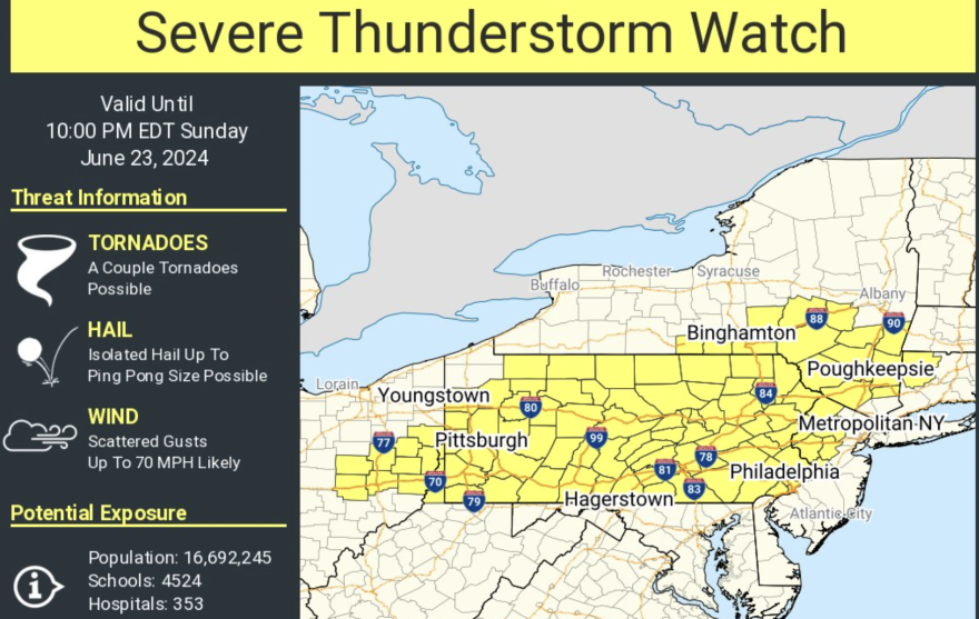
The National Weather Service has issued a severe thunderstorm watch for the Lehigh Valley and most of Pennsylvania until 10 o’clock tonight.
It comes amid a heat wave that looks to break Monday as a cooler air mass moves into the region Sunday night into Monday morning.
Already by 2 p.m. Sunday, record high temperatures were reached in Atlantic City, Philadelphia and Reading when all three hit 98 degrees.
Philadelphia’s record high for the date stood since 1888, according to the weather service. Reading hadn’t been that hot for the date since 1908.
Heat index values between 100 and 110 were observed across the Northeast by mid-afternoon, according to the weather service.
“Pay attention to the skies and keep a source of weather information handy into the evening.”National Weather Service forecast discussion
In the Lehigh Valley, a cold front will pass the area Sunday night and bring with it the chance of showers and thunderstorms, the weather service said. Heavy rainfall is possible in some spots, with damaging winds, hail and lightning possible.
“Pay attention to the skies and keep a source of weather information handy into the evening,” said the latest weather service forecast discussion.
A severe thunderstorm watch has been issued for parts of Connecticut, New Jersey, New York, Ohio, Pennsylvania and West Virginia until 10 PM EDT pic.twitter.com/LFcqd3104K
— NWS Mount Holly (@NWS_MountHolly) June 23, 2024
Monday’s weather will be noticeably different from most of the past week. The Allentown area will be mostly sunny with a high of 78.
The heat will crank back up Tuesday with a high of 89 in the forecast, going up to 93 on Wednesday, the weather service said.
A chance of showers and thunderstorms after 2 p.m. Wednesday will bring with it cooler weather with highs in the 80s the rest of the week, according to the forecast.