BETHLEHEM, Pa. — It'll be a windy one tonight.
And there could be a snowy night later this week.
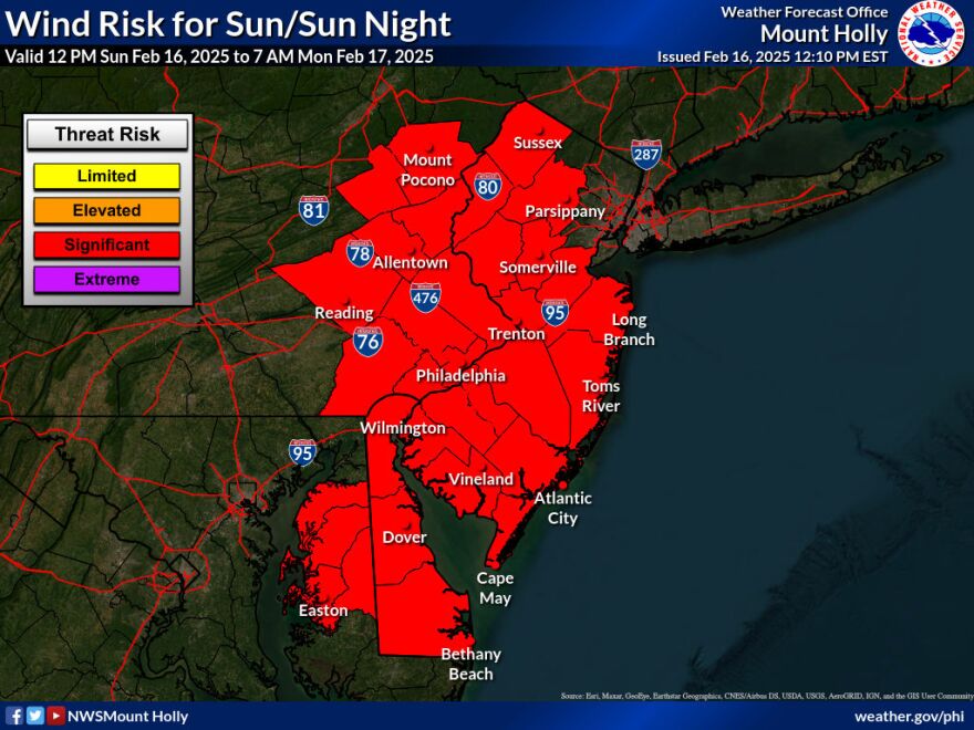
The latest forecast from the National Weather Service in Mount Holly, New Jersey, released Sunday morning, said the area still is expected to see wind gusts upwards of 60 mph tonight into Monday.
But it's too far out to tell how much snowfall the Lehigh Valley could see in the latter half of the week.
"Damaging winds will blow down trees and power lines Widespread power outages are expected."National Weather Service warning
The NWS released the high wind warning early Saturday, alerting residents of "West winds 25 to 35 mph with gusts of 50 to 60 mph expected," for Lehigh and Northampton counties from 1 p.m. Sunday to 6 a.m. Monday.
The warning isn't only extended to surrounding areas — it's in effect for east central Pennsylvania too. The NWS urges those who must travel to drive with caution.
"Damaging winds will blow down trees and power lines," the warning says. "Widespread power outages are expected. Travel will be difficult, especially for high profile vehicles."
'Accumulated gust of wind'
For updated power outage information, PPL Electricity customers can view the company's power outage map and Met-Ed customers can view their power outage map or go to www.outages.pa.firstenergycorp.com.
PPL customers can report an outage on the PPL website and can also navigate to the power outage map there. Met-Ed customers can report an outage on its website.
⚠️⛈️🌬️ A powerful storm system will impact the region today into tonight. Periods of moderate to heavy rain today and thunder possible through this afternoon. High winds developing this afternoon and evening, persisting through Monday. #PAwx #NJwx #DEwx #MDwx pic.twitter.com/dGwB0BNAS7
— NWS Mount Holly (@NWS_MountHolly) February 16, 2025
The strongest gusts (50-60 mph) are expected to roll in between 4 to 10 p.m. Sunday, with winds upwards of 25-40 mph, according to the briefing.
Wind gusts then lower to 40-50 mph later tonight through Monday.
Wet conditions this weekend, combined with high winds "could result in extensive tree damage," the NWS said.
EPAWA meteorologist Bobby Martrich described Sunday's event as a "wind gust swath," in his latest video.
"So this is taking all the areas in our region and it's doing an accumulated gust of wind that goes through this evening," Martrich said.
He described the worst of the gusts as passing through a corridor between southeastern Pennsylvania, Maryland, northern most parts of Virginia and West Virginia, and most of New Jersey.
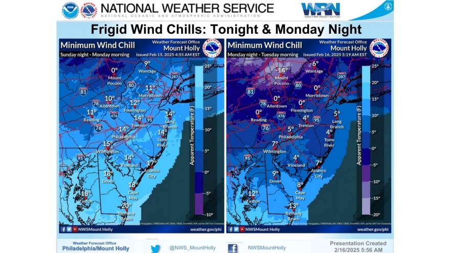
Wind chills expected
The weather service says impacts could be "exacerbated," with strong winds both increasing chances for power outages and ushering in "much colder air, with temperatures in the 20s and 30s and wind chills in the teens."
"The initial surge is really what's gonna give you the power outage concerns," Martrich said.
Noting the potential for gusts up to 60 mph, Martrich said he expects to see gusts of 50-55 mph within "that first surge."
The "apparent feel" from Sunday night into Monday morning will be around 10 degrees from the minimum wind chill, a graphic from the NWS shows.
Conditions won't let up much going into Tuesday, either.
High winds are expected to continue into Monday, with 20-30 mph winds and gusts near 40-50 mph in the afternoon.
Monday night into Tuesday morning, the wind chill will drop temperatures to feel around 0 degrees, with the northern most areas of the Lehigh Valley dipping below that.
"However, with strong cold air advection behind today's cold front, wind chills both Monday night and Tuesday night could get close to cold weather advisory conditions," a forecast discussion from the NWS says.
"Minimum wind chills both nights are expected to be in the single digits above zero generally for the coastal plain, and below zero for areas north and west of the fall line."
More snow on the way?
Late Wednesday into Thursday shows a potential for more snow, with lower chances for "significant" snowfall totals, the briefing says.
The local forecast as of Sunday afternoon reported a 50% chance of snow during that timeframe.=
"Still a lot of uncertainty if and where we will see significant snowfall."National Weather Service, Mt. Holly
A graphic in the NWS briefing shows the Lehigh Valley has a 32% chance for more than 4 inches of snow and a 14% chance of over a foot of snow Wednesday into Thursday.
"Still a lot of uncertainty if and where we will see significant snowfall," the briefing says. "Too early for exact forecast totals!"
Martrich said the area could see "above average snowfall, that we're projecting for the month of February," which he previously called the "snowiest" month of the year.
"This is going to be highly — very highly — contingent on this Thursday system everybody's been talking about," Martrich said.