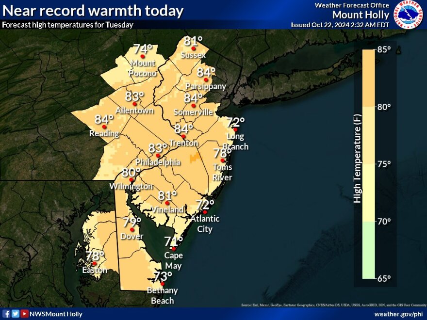
BETHLEHEM, Pa. — Our pattern of sunny days rolls on in the Lehigh Valley, with fall suddenly feeling a lot more like summer.
The National Weather Service said record-high temperatures are possible Tuesday, with winds out of the south setting up for the afternoon.
“It will feel more like a mid-to-late August day, with highs in the low to mid 80s under clear skies,” the weather service said in its latest forecast discussion.
It said records could fall for climate stations across the region.
In Allentown, the forecast high Tuesday is 83 degrees, or 20 degrees above average.
The record high for the date is 84 degrees, set in 1979.
Atlantic City, Philadelphia, Reading, Trenton and Wilmington also are among the areas expected to challenge records Tuesday.
“The humidity won’t be too high, and this isn’t the same thing as July [and] 84 degrees,” EPAWA meteorologist Bobby Martrich said in his latest video update.
“It’s going to be hot, don’t get me wrong, but it’s not going to be super humid,” Martrich said.
Wednesday will continue the trend of above-average temperatures, with highs topping out in the mid to upper 70s for most areas.
Cold front Thursday
“We do have a cold front that’s going to approach the region [Thursday] and this is going to fall apart,” Martrich said.
“Unfortunately, we don’t have any rain really projected with this, except maybe nearest the New York-Pennsylvania border north of the I-80 corridor.”
Martrich said highs will fall back into a much more autumn-like low- to middle-60s, and more dry weather is ahead for the long-term.
According to the weather service, there will be two days of above-normal temperatures on Friday and Saturday, followed by two days of near-normal temperatures.
Readings on Saturday will be the warmest of the period, the forecast discussion said, with highs in the mid to upper 60s for the Lehigh Valley and low 70s for the Philadelphia metro area.
Driest October ever?
Not only has precipitation been well below the historical average this month, the Allentown area is on pace for one of its driest Octobers on record.
However, even if we fail to get another drop of rain this month, it may not be our driest October of all time.
According to National Weather Service data going back to 1922, the area was bone dry throughout October 1924, though only 92% of data is available for the period.
Records show the total rainfall that month was officially 0, while this month the climate site at Lehigh Valley International Airport has recorded 1/100th of an inch of rain, making it our second-driest October ever (perhaps, with an asterisk).


