BETHLEHEM, Pa. — The Lehigh Valley could see more rain this week than it’s had in the past two months, with an increasingly tropical air mass triggering a number of weather concerns, from damaging winds and large hail to flooding.
The National Weather Service said a cold front will begin to cross through the region Tuesday before stalling over the Mid-Atlantic into the end of the week.
Meanwhile, Tropical Storm Debby is expected to gradually lift north, dominating our weather pattern and leading to days of soaking rain from a system crawling northeast at just 6 mph.

The slow rate of movement is expected to bring catastrophic flooding across southeast Georgia and the coastal plain of South Carolina, forecasters say, before the storm surges into the area later this week.
Here’s a breakdown of the expected impacts:
Tuesday into Wednesday
A flood watch remains in effect from 2 p.m. Tuesday through Wednesday morning, along with a severe thunderstorm watch in effect until 11 p.m.
A severe thunderstorm watch has been issued for parts of New Jersey, New York and Pennsylvania until 11 PM EDT pic.twitter.com/v6jRTsMBNB
— NWS Mount Holly (@NWS_MountHolly) August 6, 2024
Forecasters say as the cold front approaches from the north and west, it will interact with tropical moisture associated with Debby to result in heavy downpours over the area.
Rainfall totals are expected to average 1.5 to 2.5 inches, but with locally higher amounts possibly exceeding 5 inches.
Additionally, strong-to-scattered severe thunderstorms producing damaging wind gusts and large hail are expected to develop during the afternoon hours.
On Tuesday afternoon, the Storm Prediction Center moved the Lehigh Valley from a slight to enhanced risk (3 out of 5) for severe weather, highlighting the chance for "multiple clusters of intense convection capable of damaging winds and large hail."

A tornado or two cannot be ruled out, the SPC said.
“The main widespread flooding threat will not really get going until tonight,” the National Weather Service said, highlighting a predecessor rainfall event that will set up over the area through Wednesday morning.
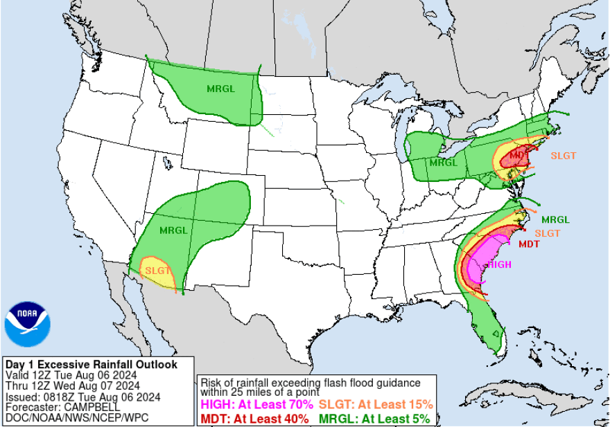
The Weather Prediction Center has a moderate risk (3 out of 4) for excessive rain, particularly in the areas where the flood watch is in effect.
Late week
“There’s a big trough coming in that’s going to end up picking this [tropical storm] up and sending it off to the north and east,” EPAWA meteorologist Bobby Martrich said in his latest update.
Martrich said the timing of the heaviest rainfall for the Lehigh Valley area looks like it’s going to be on Friday and Friday night.
“For areas that get hit hard Tuesday, it looks like you’re going to get hit hard again … that’s where we’re going to have some flooding issues,” he said, with the expectation that weather service will continue flood watches across the region.
Some models suggest total rainfall of more than 6 to 7 inches in some areas by the end of the week.
The Lehigh Valley has recorded just 6.47 inches of rain since June 1.


