- Long-range forecasters are in the process of fine-tuning their winter outlooks
- The Climate Prediction Center's seasonal outlooks offers clues to which way winter is leaning
- Superblends are showing that cold air may be at a premium for our area
BETHLEHEM, Pa. – In offices around the globe, meteorologists and climatologists are busy working on the most highly anticipated seasonal outlook of the year, all to answer one very big question.
How much snow is coming this winter?
But if you think the answer to that question is an easy one, guess again. The process involves veteran long-range forecasters, climatologists and researchers analyzing computer models and looking at how previous winters have played out.
There are also other factors that are primary drivers of an annual winter outlook, such as El Niño or La Niña, and whether the polar vortex will unleash Arctic air that plunges into the U.S. (*if you’re a fan of a warmer winter, you’ll prefer a strong polar vortex. But if you like cold and snow, root for signs of a weak/disrupted polar vortex).
So what are experts saying as they gather more clues on the upcoming winter season?
Another mild winter?
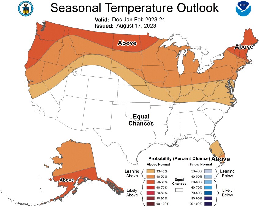
While the National Oceanic and Atmospheric Administration has yet to release an official winter outlook, its Climate Prediction Center can already tell us which way winter is leaning in terms of predicted temperatures.

The latest seasonal outlooks predict milder-than-average conditions from the Mid-Atlantic through the Northeast – and across the entire Northern Tier. Maps show these areas to have the greatest chance of warmer-than-normal conditions through the entirety of the winter season.
Precipitation amounts are leaning above average, but not by much. In fact, the Lehigh Valley is a tossup when it comes to probability, nearly straddling the line between “equal chances” of either above normal or below normal precipitation.
What the superblends are saying
There are multi-model ensembles being used by leading forecasters, and these are sometimes referred to as superblends.
One superblend is a combination of the UKMet model (operated by the United Kingdom METeorological Agency) and the ECMWF (the European Center for Medium-Range Weather Forecasts).
Ben Noll, a meteorologist at the National Institute of Water & Atmospheric Research, recently said on X (formerly Twitter) that the ECMWF+UKMET superblend for Dec. 2023 – Feb. 2024 is very active along the U.S. East Coast.
The ECMWF+UKMET superblend* for December 2023-February 2024 is very active along the U.S. East Coast ❄️
— Ben Noll (@BenNollWeather) September 11, 2023
Consistent with an El Niño winter, above normal precipitation (🟢) is shown across the Deep South, Southeast, Florida, Mid-Atlantic, and Northeast as well as California.
The… pic.twitter.com/7gHvX121Rr
“The risk for East Coast storms looks higher than normal, but cold air may be at a premium!” Noll said, noting the superbend consists of 110 ensemble members and comprise two of the best seasonal modeling systems.
The superblend shared by Noll looks almost identical to the outlooks above, with above-normal precipitation across the Deep South, Southeast, Florida and Mid-Atlantic. But those odds appear to taper off in the Lehigh Valley.
What about El Niño?
The past two winters have proven mild and, in many cases, snow has been scarce. But things could change this winter.
Because of El Niño – the episodic warming of the eastern and central tropical Pacific Ocean – we see the favoring of above-average amounts of precipitation creeping up the East Coast through the Mid-Atlantic.
Historically, El Niño has increased precipitation amounts during winter – and sometimes snowfall as well. But the amount of snow has depended on the strength of El Niño, with strong events tilting the odds toward heavy snow in the region.
According to the latest diagnostic discussion from the Climate Prediction Center, “El Niño will persist through the Northern Hemisphere winter 2023-24. Given recent developments, forecasters are more confident in a ‘strong’ El Niño event.”
The last time there was a strong El Niño, in the winter of 2015-16, the Mid-Atlantic had a blockbuster snow event known as “Snowzilla” or the “Blizzard of 2016.” It dumped almost 32 inches of snow in the Lehigh Valley, or a season’s worth of snow in one storm.
That winter also ended up being the warmest on record at the time for the Lower 48, despite the massive storm, showing what can happen when precipitation and cold air meet up at just the right time.


