BETHLEHEM, Pa. — The National Weather Service said Tuesday will be “the calm before the storm” in the Lehigh Valley, ushering in what looks to be a full change of season for the area.
The greatest risks for severe weather on Wednesday should fall south of the area, though potential exists for a few strong to severe wind gusts to occur, forecasters said.
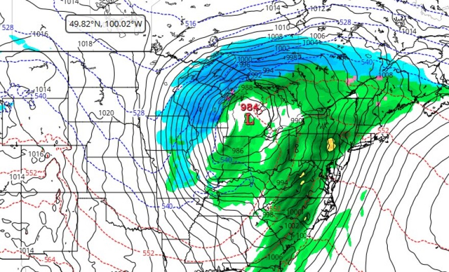
It will come at the tail end of a multi-day severe weather event as a strong storm system marches from the Central Plains to the Great Lakes on Monday and Tuesday before targeting our region.
It also comes at a time of year when severe weather becomes more routine, with the months of March through June known as the busiest for tornadoes across the United States.
The setup
After a chilly Monday, a southerly flow of air will return to the region Tuesday, the weather service said.
Winds are expected to be gusty at times, upwards of 20 to 25 mph, with a mix of sun and clouds expected as temperatures push into the 50s.
On Wednesday, mild conditions again are in store, with temperatures in the 50s and 60s, with periods of rain expected, the weather service said.
But the jet stream dipping south will bring cold air from Canada, and warm air and moisture advection from the Gulf will be a nasty combination once they clash, forecasters say.
2:16am CST #SPC Day3 Outlook Slight Risk: Wednesday across the Mid Atlantic https://t.co/K89lXjsUbi pic.twitter.com/L1rboFJ0pM
— NWS Storm Prediction Center (@NWSSPC) March 3, 2025
“With such a strong wind field in place, if there are any breaks in precipitation and further destabilization occurs, these higher winds aloft may be able to be tapped and brought down to the surface,” the latest NWS forecast discussion said.
The Storm Prediction Center has outlined a slight risk (2 out of 5) of severe weather for parts of the region Wednesday, mainly across the Delmarva.
The rest of the forecast area, including the Lehigh Valley, is in a marginal risk (1 out of 5) for severe weather.
In terms of rainfall, amounts of 1 to 2 inches are expected, with localized higher amounts possible.
Closing the door on winter?
“There are just no significant wintry prospects that we have to cover here going forward,” EPAWA meteorologist Bobby Martrich said in his latest video update.
March 1 marked our transition to meteorological spring, meaning the coldest three months of the year are behind us.
We can now look forward to three months of “rapid warming,” the weather service said.
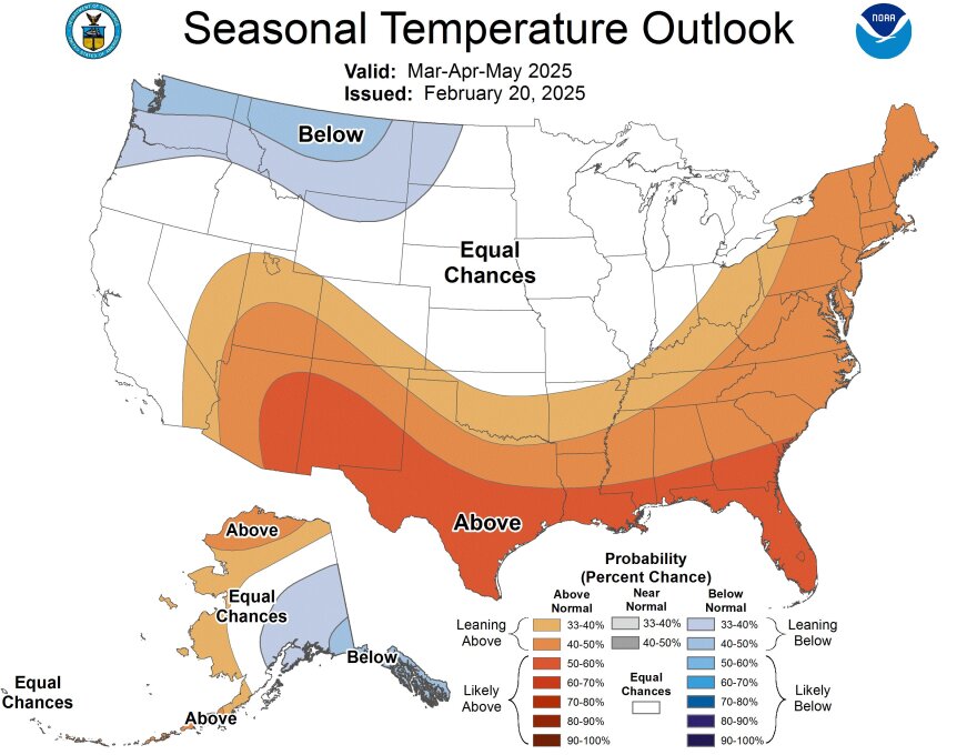
The seasonal outlook from the Climate Prediction Center shows a strong probability of above-average temperatures for the Lehigh Valley, along with equal chances for precipitation.