BETHLEHEM, Pa. — You wouldn’t know it from stepping outside, but we’re still a little more than a month away from the fall equinox.
But if you double-checked the date on the calendar this morning, rest assured it said Aug. 20 — even as temperatures will struggle to warm to 70 degrees on what should be a mostly sunny and rain-free day.
“We have cooler air coming in," EPAWA meteorologist Bobby Martrich said in his latest video update. "Cooler air and refreshing air coming in for the next several days.”
The temperature spread across the region should be 68 to 74, Martrich said, including a projected high of 69 in the Lehigh Valley.
That's impressively cooler than our average high for the date, which typically sits in the low 80s.
Wednesday should feel much the same, and it’s not just the daytime highs bringing relief from summer heat and humidity.
Forecasters say the air mass actually is anomalously cool for this time of year, and much more comparable to the fall.
The main culprit is multiple ridges over central/western Canada, with air quickly being transported south and heading straight into the mid-Atlantic region, atmospheric scientist Tomer Burg said on X.
A fall feeling
Overall, quiet weather and below-normal temperatures are expected all the way through Thursday night, according to both Martrich and the National Weather Service.
An even better measure of how anomalous the air mass is would be to look at our projected overnight lows for the next few days.
“We have some lows overnight tonight that are getting into the 40s in some places, especially when you get across the Poconos and the higher elevations,” Martrich said.
“It’s going to be a big change from what we’ve had here over the past several months. This is actually comparable to early October.”
A forecast low of 50 in the Lehigh Valley would be just 4 degrees shy of the record low of 46 for Wednesday's date.
The low also is projected to fall to 51 on Thursday morning.
How weird is the weather?
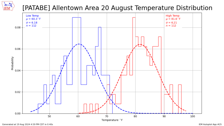
Below, the featured chart presents a histogram of reported daily high and low temperatures on Aug. 20 for the climate site at Lehigh Valley International Airport.
A simple normal distribution line is plotted based on the computed mean temperature and standard deviation from the mean.

But factoring in local climatological data from 2024, the average high so far in August has been about 84 and the average low about 64.
That means both our daytime highs and overnight lows the next few days could be 10 to 15 degrees below normal.
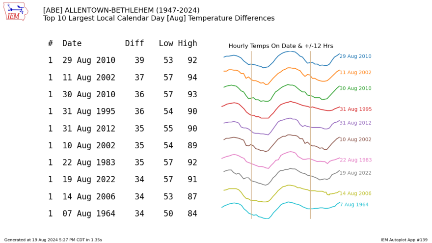
Meanwhile, the next chart presents the Top 10 largest differences in daily high and low temperature for the Allentown area in August.

While the temperature spread expected this week wouldn't make the Top 10, the spread between our highest temperature — 94 on Aug. 1 — and our projected lows this week is a difference of about 44 degrees.


