- The National Weather Service has established new criteria for winter storm watches and warnings
- The changes are effective immediately for the upcoming winter season, officials said
- The new criteria will be used by all 122 NWS weather forecast offices
BETHLEHEM, Pa. — Weeks away from the official start of winter, the National Weather Service has established new winter storm warning criteria, officials confirmed Monday.
The criteria will serve as the basis for issuing winter storm watches and warnings across the country, according to Maureen O’Leary, deputy director of public affairs for the NWS.
It will be used by all 122 NWS weather forecast offices beginning this winter season.
A document shared with LehighValleyNews.com said the goal of establishing the new criteria is to increase consistency among neighboring offices and better align snowfall watch/warning criteria for the climatology of the region.
“Greater consistency will help promote more collaborative and streamlined public and partner messaging with respect to winter storms,” the document said.
What’s changing for the Lehigh Valley?
Effective immediately, each NWS forecast office is expected to implement the new winter storm watch and warning criteria across its county warning area.
The Lehigh Valley is part of the NWS Mount Holly county warning area, or CWA, encompassing eastern and southeastern Pennsylvania (including the Philadelphia metropolitan area), all but far northeast New Jersey, Delaware and northeastern Maryland.
Reached by phone, staff in Mount Holly said they were unable to speak to any “sweeping changes” to their criteria and referred questions to Sarah Johnson, warning coordination meteorologist.
On Tuesday morning, Johnson said it's not a significant change in operations for the office.
"It’s not a major major change for us. But instead of having these criteria with very specific time frames, now we have this one criteria and we just use it for one event," she said. "We’re not having to try and figure out if all the snow is going to fall in 12 hours or 24 hours."
In the past, the weather service issued winter storm warnings based on how much snow was expected in those time frames.
Now, the criteria will consider how much snow the area typically gets and the impacts that would result.
"It’s pretty rare we get a storm that will last a full 48 hours. That would be a bad day or a few bad days," Johnson said. "But we now have the discretion to define what a single event is."
More on the updated criteria

Generally, areas within the NWS Mount Holly CWA did not change their snowfall threshold.
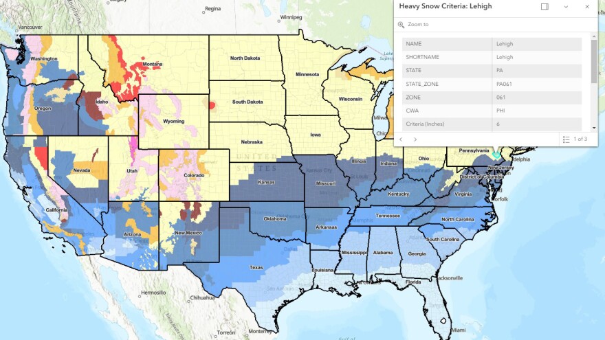
In Lehigh and Northampton counties, the criteria is 6 inches of snow under the latest guidance. In the northern tier, including the Poconos, the criteria for watches and warnings will abide by the same threshold amount.
Those thresholds can be seen in the new "Winter Storm Warning For Heavy Snow Criteria" map, on which each county now is color-coded with an assigned snowfall threshold.
To find the Winter Storm Warning Criteria for your area, check out the interactive map on the NWS website.
" The six inches was always our criteria for 12 hours. We had another criteria for 24 hours but it was almost never used," Johnson said, noting the change "standardizes things across the whole country."
Winter storm watches are issued when conditions are favorable for hazardous winter weather conditions to develop.
A winter storm warning is issued when heavy snow, significant freezing rain, or heavy sleet is expected to occur.
A caveat remains on when watches or warnings might be issued. For example, if the Lehigh Valley’s criteria is 6 inches and only 4 to 5 inches are expected, but with strong winds or a timing consideration (such as moving through the area during rush hour) then a warning might be issued.
However, if the area expects 6 inches of snow fall through the entire 48-hour window and impacts are expected to be minor, NWS offices may opt to issue an advisory rather than a watch or warning.
"Pretty much once we get to the six inches we’re probably going to issue a warning, but we do have that leeway, or that allowable margin to consider the impacts," Johnson said.


