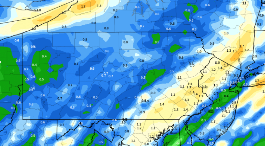
BETHLEHEM, Pa. — Another soaking rainfall and flood watch are expected for the Lehigh Valley on Friday, with widespread impacts somewhat similar to Tuesday’s storm, forecasters said.
“It’s going to be very similar to last time in terms of the synoptics of it,” EPAWA meteorologist Bobby Martrich said in his Thursday video forecast.
But Martrich also described key differences from Tuesday’s record-setting storm.
“Precipitation is not going to be nearly as much as it was on Tuesday,” he stressed. “You cut those [rainfall totals] in half, if not more.”
Thursday 1/11 and week ahead outlook, covering:
— Bobby Martrich | EPAWA (@epawawx) January 11, 2024
■ Breakdown of Friday night system timing/impacts
■ Rain, wind, snow, and timing expectations shown
■ Model differences with next week's snow chanceshttps://t.co/SRAxyWvgft
However, the National Weather Service on Thursday afternoon issued a flood watch that will stretch from Friday evening into Saturday morning.
All of Lehigh and Northampton counties are included in the watch.
"Flooding caused by excessive rainfall is possible," it said, from 7 p.m. Friday through 7 a.m. Saturday.
"Excessive runoff may result in flooding of rivers, creeks, streams, and other low-lying and flood-prone locations.
"Flooding may occur in poor drainage and urban areas. Area creeks and streams are running high and could flood with more heavy rain," it said.
The setup
A low-pressure system will track toward the Great Lakes on Friday night, with a warm front pushing through the mid-Atlantic region during the overnight hours.
The National Weather Service said rainfall should rapidly overspread the region, with a strong south-to-southeast low-level jet “advecting in a rich plume of deep moisture from the Atlantic.”
A low-level jet describes a region of relatively strong winds in the lower part of the atmosphere. In combination with the moisture, it will “bring periods of moderate to at times heavy rainfall across the area,” the weather service said in its latest forecast discussion.
It said the flood risk will remain high over the weekend for parts of the region, mainly along main stem rivers due to stream flows being extremely high.
Timing, totals, other impacts
The Weather Prediction Center has most of eastern Pennsylvania, New Jersey and parts of the Delmarva in a slight (2/4) risk of excessive rainfall, with precipitation moving in near the end of the evening rush Friday.
The Lehigh Valley is expecting a widespread 1 to 1.5 inches of rain, or perhaps a bit less, with Martrich putting storm totals on "either side of an inch."

“The wind isn’t quite as high end as it was during [Tuesday’s] event,” Matrich said, but he noted the Lehigh Valley still could see strong wind gusts and cold air advection coming in behind the system on Saturday that will lead to another windy day.
“We have a lot of cold air coming in,” he said. “A lot colder than we have been.”
In all, while conditions are forecast to be generally less severe than Tuesday’s system, additional flooding, tree damage and power outages remain a concern due to soil being extremely saturated.
True winter cold ahead (and snow?)
Forecasters say each one of those storm systems is tugging cold Arctic air out of Canada, into the western and central United States, and a little bit closer to the Lehigh Valley.
The morning high of 50 degrees on Saturday is expected to fall off rapidly, with winds out of the west at 20 to 30 mph and higher gusts possible.
By next week, a true blast of winter is likely, with daytime highs in the 20s and overnight lows in the teens toward midweek.
Forecasters say guidance also shows strong potential for accumulating snow across the region Tuesday into Wednesday, but models still are working out the timing, placement and the progressive nature of the system.


