
BETHLEHEM, Pa. — Sweltering conditions in the Lehigh Valley are forecast to end with a bang Saturday, according to the Storm Prediction Center.
But the region needs to make it through Friday first, and local meteorologist Bobby Martrich has some advice as a Bermuda High remains anchored off the coast, pumping warm, moist air into the region.
- The Lehigh Valley will see another day of high heat and humidity, with the heat index pushing into the triple digits
- It comes as excessive heat flags remain in place for much of the region
- Strong storms are expected Saturday, with wind damage the main threat
“Take it easy. Don’t be a hero,” Martrich said in his morning forecast video. “Drink plenty of water, take rest and shade if you have to work outside. If you have the ability to access air conditioning, use it.”
EPAWA's 7/28 and week ahead outlook, covering:
— Bobby Martrich | EPAWA (@epawawx) July 28, 2023
■ Heat and humidity peak today across the region
■ Cold front arrives Saturday with scattered storms
■ Cooler temps and comfortable humidity followshttps://t.co/K5M7f4GhPc
Martrich described high temperatures Friday that will be in the 90s across the region, with heat index values pushing well into the triple digits.
“You don’t want to overdo it today," he said. "Any kind of strenuous activity, do it very early."
It comes as excessive heat flags remain in place for much of the area through Friday night.
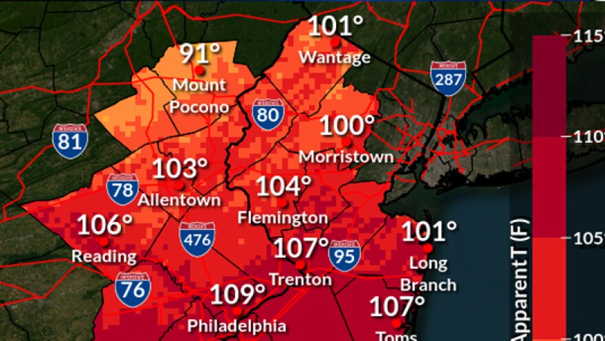
According to the National Weather Service, the day likely will have the hottest combination of heat and humidity of this stretch, with apparent temperatures — what it feels like outside — in the 100- to 110-degree range in most areas and 90s for the southern Poconos.
Hot spell or heat wave?
By a long-held definition, a heat wave in the Mid-Atlantic region has been recognized as three consecutive days with temperatures at or above 90 degrees.
But temperatures in the Lehigh Valley on Wednesday and Thursday reached 86 and 89, respectively, with a “feels like” temperature in the mid to upper 90s.
So is this truly a heat wave, or is it a hot spell?
The weather service also recognizes that when thresholds of daytime high and nighttime low heat index values are exceeded for at least two consecutive days, it also can be considered a heat wave.
That’s because it recognizes a generalized estimate of the onset of physiological stress. And while the thresholds can't be applied directly nationwide, they often are applied when a combination of heat and humidity causes temporary modifications in lifestyle and where adverse health consequences are likely for the affected population.
In this case, we are likely to be considered in a de facto heat wave — especially with the Lehigh Valley having no designated cooling centers or cooling stations.
A stormy Saturday
Widely scattered showers and thunderstorms likely will be ongoing across parts of the Northeast, near or behind a cold front forecast to push through during the day on Saturday.
Storms likely will begin to develop by midday as the air mass destabilizes, according to the Storm Prediction Center, with several clusters likely to evolve and move through the Lehigh Valley area during the afternoon.
12:53am CDT #SPC Day2 Outlook Slight Risk: for southern New England into the Mid Atlantic states, north-central Great Plains https://t.co/Y1WiOd8TQQ pic.twitter.com/ojNwTwP3NP
— NWS Storm Prediction Center (@NWSSPC) July 28, 2023
Stronger storms will be capable of isolated 60 to 65 mph wind gusts, resulting in widely scattered wind damage, the SPC said. There also is a small chance of tornadoes spinning up.
Drier and much cooler air will move in behind the storms.
“We’re going to have some pretty nice weather,” Martrich said. “I know some of you are just really gung-ho about the heat and humidity. We are going to get some back again, eventually.
"I just don’t think the first half of August is going to support a lot of high heat type stuff.”
