BETHLEHEM, Pa. — Beware of things that go crunch.
Dry leaves and brush, to be exact.
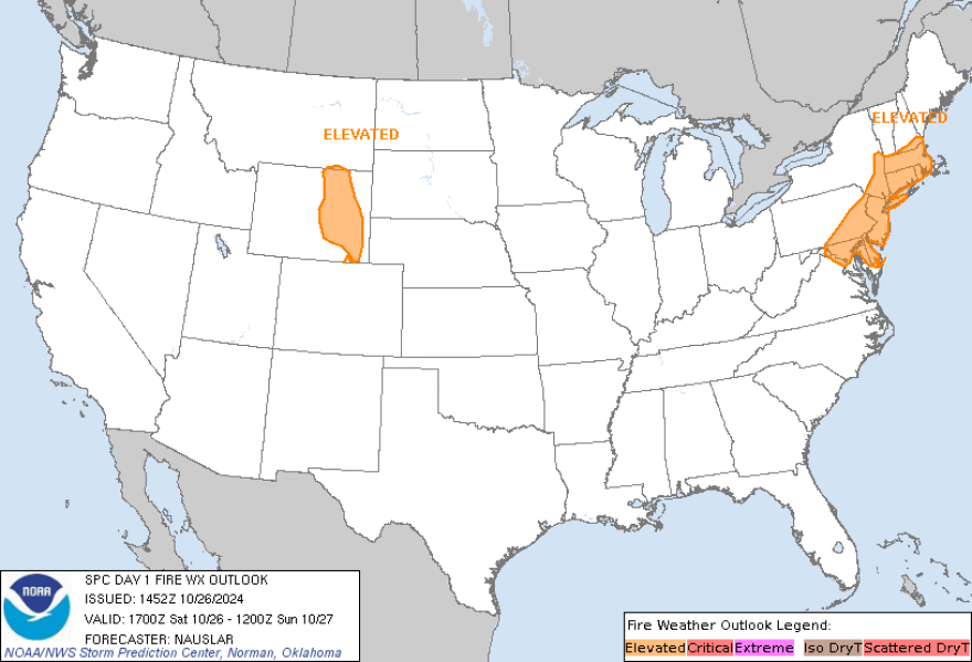
For the first time, the Lehigh Valley is part of the Storm Prediction Center's National Fire Outlook map today.
The National Weather Service at 10 a.m. Saturday issued its usual zone forecast, and the earliest chance of rain in Northampton and Lehigh counties, and surrounding areas, it says, isn’t expected until at least the latter part of Thursday.
And the chances are a bit slim – between 30 and 40 percent, according to Saturday's zone forecast.
Nick Nauslar, fire science and operations officer with the NWS Storm Prediction Center emphasizes using common sense when outside.
“By some measures, we are experiencing record-high fire danger this year, and there are gusty northwest winds with low humidity that's creating some locally critical fire weather conditions,” said Nauslar Saturday via phone.
“When we have these sorts of conditions, it’s always best to avoid any outdoor burning and using any equipment around dry grass and brush. It’s always good to keep your lawn and areas around you free from fuel or dry fuel buildup.
“Being conscious and careful when outside.”
The current climate site at Lehigh Valley International Airport recorded 2/100ths of an inch of rain. A mere blip over the the 1/100th of an inch of rain recorded last week made this month possibly our second-driest October ever.
Quite the departure from the normal rainfall of almost three and a half inches.
Combined with sunny and windy conditions today and through the weekend, with low winds but gusts up to 25 miles per hour at times, and no rain in sight – and temperatures of late reaching mid-80s, 20 degrees above average for this time of year – it’s a situation ripe for fire to easily start.
“We have a cold front coming, so it’s going to get a little bit colder, and there’s a freeze warning close to us, and with that comes drier air and some gusty winds,” said Nauslar of the Lehigh Valley outlook.
For those who don’t know, a front is just kind of a transition zone between two different air masses, said Nauslar.
“Sometimes it can be mostly a wind shift, from southerly to westerly and northerly, or you can have kind of a more humid, warmer air mass, and then a front comes through and it gets colder and drier and windier behind it,” he said.
“It always takes some sort of spark, like a catalytic converter, outdoor burning, recreational patio fires, or hunters out and about. And it’s dry, there’s leaf drop, more fuel available, leaves on the ground, the crunch crunch, that’s the main concern.”
Several towns in the Lehigh Valley have issued burn bans due to recent dry weather.
Berks and Hunterdon counties, among others outlying the Lehigh Valley, have issued Red Flag warnings until later Saturday. Due to 30 mph winds predicted, the NWS has issued warnings over New York, New Jersey, Massachusetts and Connecticut and other states.
In the wake of the front extending from the Northeast Coast to the Mid-Atlantic that will move eastward over the Atlantic, scattered light rain could develop in parts of the Northeast through Saturday night.
But not us. The Lehigh Valley will be dry and breezy today, tomorrow and perhaps Monday, but not looking like a chance of rain til mid-late next week.
Sun and temperatures will reach the lower 60s today, paired with 10-15 mph winds and gusts up to 25 miles per hour.
The NWS forecast for the rest of the weekend is the same. Sunny, pleasant and breezy during the day and clear, cold and with west winds around five mph.