SOUTH WHITEHALL TWP., Pa. — A wide-reaching comprehensive plan for how South Whitehall Township will grow in the next 10-15 years looks to preserve more land, cluster new development and especially reduce industrial growth in the northeastern township.
It also sets as priorities examining traffic safety and transportation infrastructure, and upgrading sewage facilities.
- South Whitehall Township has published a new comprehensive plan for the municipality, updating the previous 2009 plan
- The plan takes care to emphasize goals for land use and development, touching on other infrastructure and transportation needs as well
- The plan is subject to a 45-day public comment period before potential approval
Township officials spent nearly four years working on the plan, which looks into the growing the municipality's future and controlling development.
It paints a picture of growth and expansion into more specialized developments for the township in the last decade, such as Ridge Farm and Hills at Winchester.
With a population increase of about 10%, increase in jobs of 23% and more than 500 new housing units since the prior comprehensive plan assessment in 2009, South Whitehall is younger and fuller than it was a decade prior, the plan says.
The draft plan now seeks public comment and input. A copy also is available for review in the Township Municipal Building at 4444 Walbert Ave.
Township Community Development Director David Manhardt said the public comment period will last at least 45 days. Absent substantive changes, in coming months the township Board of Commissioners likely will hold a public hearing to adopt the final plan.
What is a comprehensive plan?
A comprehensive plan sets out long- and short-term goals for housing, transportation, infrastructure, preservation, zoning and other aspects of a municipality, and will inform new ordinances.
In other words, it is a guideline for where future efforts and developments should go and what they should be like.
It also assesses the trajectory of transportation, developments, demographics, employment and other key aspects of the area.
The plan's assessment kicked off in March 2019 and continued with in-person and virtual meetings taking community input. Open house meetings were held earlier this year to receive in-person feedback and suggestions.
Township Planner Gregg Adams said participating in the creation of the plan is the main way residents of South Whitehall can stop future development they won’t like.
“Once this is adopted and the zoning ordinances change, basically it's a lot harder to stop development,” Adams said in September during the process of creating the draft.
Highest priorities, implementations
The plan lists priorities and timetables for proposed action items on each subject examined. Many high priority items include infrastructure, bureaucratic reorganization and zoning.
The highest priority aspects of the plan include:
- Developing a plan for safe and efficient bicycle and pedestrian connectivity
- Evaluating roles and duties of municipal boards, committees and subcommittees
- Integrating capital improvements budgeting and planning across departments
- Evaluating municipal services and utilities for expansion and functionality
- Updating the official township map
- A public safety evaluation
- Updating sewage facilities plan per DEP requirements
- Examining traffic safety by identifying high crash and priority safety improvement areas
- Examining transportation infrastructure
- Updating the zoning ordinance to be consistent with the plan
There are also calls for the creation or updating of other plans for the township to implement, such as:
- Active transportation plan for bicycles and pedestrian interconnectivity and mobility
- Written farmland preservation strategies plan
- High-speed internet (5G) availability inventory
- Unified Capital Improvements plan
- Historic Preservation plan
- Written plan for open space preservation
- Creating a new official map of the township
- Township-wide stormwater management plan
- Investigation of watershed plans for the Jordan Creek, Coplay Creek and Little Lehigh Creek watersheds
- Townshipwide or multi-municipal traffic safety plan
- Transportation and traffic control plan
The plan also sets out to implement priority recommendation of the township's Parks and Recreation plan.
Development drama
Development has been among the most controversial issues in South Whitehall Township politics in recent years.
Tensions came to a head in late 2017, when the proposed mixed-use development Ridge Farms sparked controversy, with hundreds of residents coming to township meetings to try to stop the development.
“If you care about how the township is growing, going to grow in the next ten years, this is something you should be concerned with."Gregg Adams, township planner
But township commissioners couldn't legally prevent it from being developed because it followed the ordinances of the township. Once zoning ordinances are in place, it can be very difficult — sometimes impossible — for the township to stop developments that follow those ordinances.
“People have to understand that you can't come out and just say, ‘I don't like this, can we can we stop this,’” Adams said as the plan was developing. “The problem is you can't. So the comprehensive plan is really your chance to say, ‘This is how I want to see the township grow.'
“If you care about how the township is growing, going to grow in the next ten years, this is something you should be concerned with,” Adams said.
The plan examines future land use, and how that should be implemented in future Subdivision and Land Development Ordinance and Zoning Ordinance legislation.
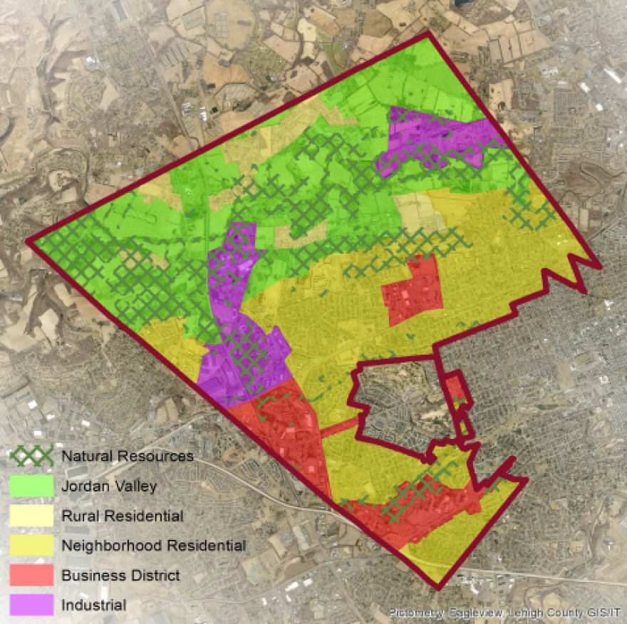
The plan establishes 12 place types to describe future land uses, such as rural, multi-family residential, industrial and conservation subdivision, to create a common understanding of what types of development should be encouraged in each category.
It says updating zoning ordinances to be consistent with the land use segment of the comprehensive plan is of high priority, and is set to be done within a year or two.

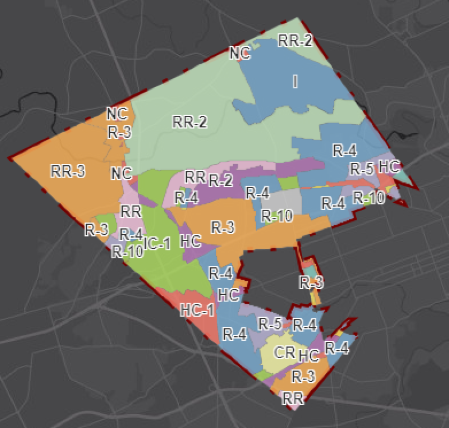
The draft land use map does not differ much from the current zoning map of the township. However, it does include a smaller industrial use section in the northeastern corner of the township than the current zoning map.

This year, a sketch plan for a potential industrial development in that area sparked some controversy, with residents arguing it would increase traffic.
Manhardt said the land use plan was not made with any specific developments in mind, and any zoning changes made from the comprehensive plan would be a long process with a lot of review.
Open space preservation
The plan lists developing a "transfer of development rights" program in the township as a goal.
The program would conserve land by sending a proposed development to a receiving area that has been determined to be more appropriate for denser development. The plan says that would help preserve open space by clustering development.
A transfer of development rights program feasibility study would need to be conducted in the coming years and would allow density credits to be applied to adaptive reuse of non-residential buildings where appropriate.
The plan also notes many considerations for preserving "the township's rural character," farmland and natural resources.
The plan says farmland often is preserved through the Lehigh County Farmland Preservation Office, and the act of retaining farmland has been a push in other nearby municipalities in recent years.
Resources and survey data used by the township in the creation of the plan can be found here.
View the draft plan in full below:
SWT Draft Comprehensive Pl by LVNewsdotcom on Scribd


