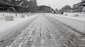
Bethlehem Live Weather Camera
This is a live look at SteelStacks in Bethlehem outside of our studio.

WEATHER-RELATED STORIES FROM THE NEWSROOM
-
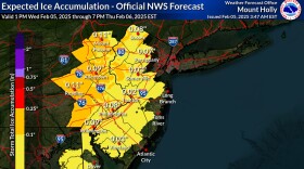
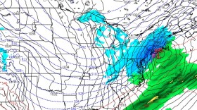
 Forecasters are calling for calling for “quite the icy slop of wintry precipitation across the region, including both sleet and freezing rain” as a quick-hitting winter storm descends upon the region late Wednesday.
 -
February is "going to be loaded,” meteorologist Bobby Martrich said, describing an “overrunning pattern” that goes through mid-month and could potentially bring the Lehigh Valley no fewer than three — and possibly four — storm chances before Valentine’s Day.
-
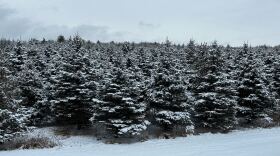
Forecasters say the Lehigh Valley should see another coating of snow to start off the "snowiest" month of the year. More snow is expected in the other half of the week.
-
The National Weather Service issued the bulletin in effect from 2 a.m. to 9 a.m. Friday for freezing rain, with total ice accumulations up to a tenth of an inch possible.
-
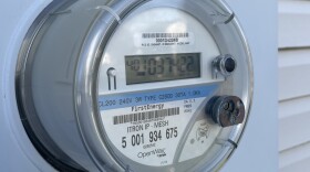
A cold snap that sent temperatures near historic lows brought record winter demand for electricity across numerous regional grids and service territories, including the Lehigh Valley.
-
“We’ve had about 13 customer calls for no water since Monday, with six of them coming in this morning,” Susan Sampson, LCA communications manager, said Thursday.
-
The wind chill was minus 11 on Tuesday morning, and a cold weather advisory remains in effect in the Lehigh Valley until Wednesday. With those temperatures, we're more like Buffalo and colder than parts of Siberia.
-
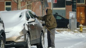
While the snow took a few hours to start piling up, by mid-afternoon it was falling at rates of two inches per hour in some parts of the Lehigh Valley. Dangerous cold will follow the snow, forecasters say.
-
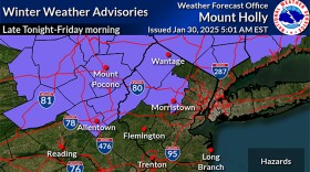
Following a Winter Storm Warning, The National Weather Service at Mount Holly, New Jersey has now issued a cold weather advisory for the Lehigh Valley and surrounding areas, warning of "dangerously cold" temperatures this week.
-
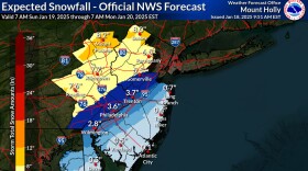
If predictions stay true, the Lehigh Valley would be on the higher end of the 4- to 7-inch range of snowfall. PennDOT and the PA Turnpike Commission have set vehicle and road restrictions.
-
Depending on how the system evolves, a robust and plowable storm seems like the more likely scenario for the region, with the timing on potential snowfall beginning to lock in for Sunday afternoon.
-
Confidence has increased for a clipper system to bring light snow to the region on Thursday, with potential for additional accumulation Sunday into Monday. The coldest air mass of the season arrives behind it, forecasters say.